Warner Mountains — whitebark pines and beyond

Warner Mountains
Conifers of the Warner Mountains. Maps from Conifers of the Pacific Slope.

The Warner Mountains are a north-south trending fault block range in the northeastern corner of California, extending northward into Oregon. The length of the range is approximately 90 miles, with the northern California portion bounded by Goose Lake on the west and Surprise Valley on the east. In California, elevations range between 5,000-9,897 feet (on Eagle Peak). In the High Grade district, which is the extreme northern limits of the Warners in California, the range has a fairly even crest of 7500 feet, reaching an elevation of 8290 feet on Mount Bidwell. This is the area where I spent four days mapping and monitoring whitebark pine (Pinus albicaulis) for the US Forest Service.

The geology of the region is complex and compelled me to understand it better. Bedrock consists of sedimentary rocks of the Oligocene overlain by rhyolitic to basaltic volcanic rocks of the Miocene. The basal andesite is overlain by rhyolite and glassy rhyolite, which are in turn overlain by basalt flows. There are valuable minerals and gems found in this area that have justified a long-standing history of mining. Gold was the first and major extracted mineral soon followed by opals, petrified wood, and even obsidian. The range is a complex assemblage of interesting rocks for sure which help sculpt the regional ecology.

The northern Warner Mountains have a long history of mining.

Continue reading “Warner Mountains — whitebark pines and beyond”

Post Eclipse Complex

Siskiyou Wilderness

Eclipse Complex
From InciWeb

It is no secret that the Siskiyous are my favorite place in the Klamath Mountains. I have spent many days and hiked numerous miles across this region. The Bigfoot Trail travels the entire crest of the range as well.

In early August 2017, lightning ignited a series of fires first named Oak, Cedar, Clear, and Prescott. These fires later grew together and were combined into the Eclipse Complex. Over the next month, approximately 100,000 acres burned in and around the Siskiyou Wilderness. Between last October and now I have had reason to visit much of this area for work and play. What follows are some of the pictures I have taken.

Continue reading “Post Eclipse Complex”

Coastal Lowland Forests

The Klamath Mountains

Coastal lowland forests of the Klamath Mountains. From the future book, The Klamath Mountains: A Natural History.

The coastal lowland forests receive the most annual rainfall of anywhere else in the Klamath Mountains. From the north in Oregon the Coquille, Rogue, and Illinois rivers drain southwest Oregon and the Smith River country is California’s only temperate rainforest. The rich soils, temperate year-round growing season, and high rainfall (often over 100 inches) nurture these impressive forests.

Klamath coastal lowland forests are typified by dense, closed canopies on well-developed soils (sometimes serpentines). The dominant tree species have high colonizing abilities, long life, and a wide ecological tolerances to environmental conditions, including dry summers with occasional persistent fog. These forest thrive below the snow belt on the extreme western slopes of the Siskiyou Mountains. Species like Douglas-fir (Pseudotsuga menziesii) and Port Orford-cedar (Chamaecyparis lawsoniana) secure the highest place in the canopy, often approaching 300’. A second canopy forms one hundred feet below and includes species like tanoak (Notholithocarpus densiflorus) and madrone (Arbutus menziesii) where they share an understory with coastal specialists like salal (Gaultheria shallon) and evergreen huckleberry (Vaccinium ovatum). With the high volumes of rain that falls each winter, banks of coastal rivers and streams are frequently disturbed and then repeatedly pioneered by red alder (Alnus rubra).

Continue reading “Coastal Lowland Forests”

Hell Gate

Botanizing the South Fork National Recreation Trail – Trinity County

Hiking Hell Gate

Hell Gate highlights the lowland interior forest of the southern Klamath Mountains along the Trinity River on the Shasta-Trinity National Forest. The Trinity is surely one of the most spectacular rivers in the state and this hike is along a roadless stretch in the upper reaches of the south fork. The old-growth Douglas-fir/mixed evergreen forest is top-notch, especially along the north-facing sections of trail. Oak woodlands are on benches above the river, with Oregon white oak mixing with picturesque grasslands–though the lack of fire is allowing extensive conifer encroachment. Some of the largest Pacific yew I have ever seen can be found along the trail as well.

The area is dotted with private in-holdings and these beautiful old homes appear at random intervals along the trail. The trail is open to biking and—for these home-owners—OHVs. Swimming opportunities abound and solitude can be easily found, especially in the winter (there are bridges on all major stream crossings). The hike, as written and drawn in Conifer Country, is 7 miles to Smokey Creek but the National Recreation Trail extends the length of this roadless stretch of river—for a total of 15 miles from Hells Gate to Wild Mad Road. The upper reaches of this trail is part of the Bigfoot Trail.

I am highlighting three species below that I found on our hike. One that is a regional endemic, one that reaches it coastal range extension here, and a third that is found across the northern hemisphere. These selections highlight the regional diversity with a biogeographical perspective.

Continue reading “Hell Gate”

The Dudleya Dilemma

We are collectors

Recently, it was announced that the California Department of Fish and Wildlife caught folks poaching Dudleya farinosa from coastal Mendocino and Humboldt counties. The tip came in from a Postmaster who noticed dirt spilling from a box being shipped to China. Conversations started, one post office talked to another, and they realized poachers were moving from post office to post office shipping boxes of the charismatic Dudleya farinosa. One of the postal workers then reported the suspicious activity on CalTip and this is now an active international poaching case.

This neatly wrapped Dudleya was confiscated by Game Wardens before it left Humboldt County on its way to Asia’s thriving succulent market. Fifty volunteers soon replanted them on the steep hillside cliffs they call home.

Continue reading “The Dudleya Dilemma”

Marine Terraces of California

In 2012 I first visited the marine terraces of coastal Mendocino County and was captivated by what I learned. The blog and graphic I cooked up after that visit has been one of the more popular entries on this website. In fact, the United States Geological Survey recently published a document on the Marine Terraces of California that features:

  • How marine terraces form
  • Soils sequences of California’s terraces
  • Where to find marine terraces of California
  • The main graphic from my blog about Mendocino’s ecological staircases

Marine Terraces of California

Find the document here:

Schulz, M., Lawrence, C., Muhs, D., Prentice, C., and Flanagan, S., 2018, Landscapes from the waves—Marine terraces of California: U.S. Geological Survey Fact Sheet 2018–3002, 4 p.

Humboldt County Wildflowers

I spoke with Cliff Berkowitz on KHUM’s Happy Trails about places to visit–starting now–to explore spectacular Humboldt County wildflowers. Flowers start flowering early because of the temperate nature of the region. This means that you can find wildflowers starting in January near the coast, all the way to June and July inland in our mountains.

Continue reading “Humboldt County Wildflowers”

Heterotrophic Plants

Parasites and Mycotrophs of the Klamath Mountains

From Wildflowers of the Trinity Alps. Photo by Ken DeCamp.

Green plants are considered autotrophs because they photosynthesize—making sugar from water and carbon dioxide. The world of heterotrophic plants is complicated but all have moved away from total energy production from photosynthesis toward obtaining organic carbon either directly from other living beings or through a parasitic relationship with a fungus. Heterotrophic plants include directly parasitic and mycotrophic forms. The conifer forests of the western United States nurture an exceptional diversity of heterotrophic plants and the Klamath Mountains may have the most heterotrophic plants in the western United States!

Continue reading “Heterotrophic Plants”

Mill Creek Wilderness

Mill Creek Wilderness The main event has been on the calendar for the past eight years. I have heard stories from friends who have actually traveled around the world to see the phenomenon–and from that alone I knew if there was and eclipse practically in our backyard, we needed to go. We selected a spot in the heart of the Ochoco National Forest and literally on the edge of the Mill Creek Wilderness in a meadow complex. The Mill Creek Wilderness Twin Pillars Trail was our hiking destination the day before the eclipse event. The wilderness protects a harsh environment typified by ancient lava flows, fire-prone conifer forests, and the Mill Creek Drainage itself. We found wonderful views across central Oregon and a fire-scared landscape on our way to the Twin Pillars. In addition, western larch (Larix occidentalis), was the conifer highlight on this adventure.

Continue reading “Mill Creek Wilderness”

Shining Rock Wilderness

Quick Facts: The Shining Rock Wilderness is in Haywood County, North Carolina and is 18,483 acres.

Old Knob Butte – Shining Rock Creek loop

Southern Appalachian Mountain Ecology

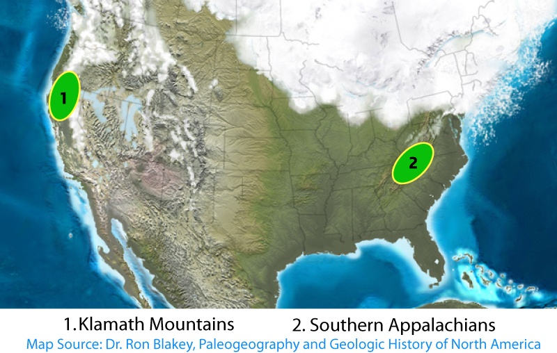
Most botanists are familiar with the ecological similarities between the southern Appalachians and the Klamath Mountains. These two regions are the two most bio-diverse temperate regions in North America. Here is as excerpt from Conifer Country:

Continue reading “Shining Rock Wilderness”

Yellow-cedar in the Siskiyous

Yellow-cedar range in northwest California.

I have begun a collaborative mapping and inventorying project for yellow-cedar in California this summer. The species is a CNPS Inventory of Rare and Endangered Plants on list 4.3 (limited distribution) in the state, with only a handful of known locations. The majority of the stands are on the Klamath National Forest but a few are also on the Six Rivers. Over the course of the summer I will be visiting a number of these populations and collecting data on stand health, reproduction, and plant associates. I made the first stop of the summer at the Bear Peak Botanical Area.

Continue reading “Yellow-cedar in the Siskiyous”

Torrey Pine Forest

Santa Rosa Island Torrey pine (Pinus torreyana ssp. insularis)

Torrey pine range map from Conifers of the Pacific Slope.

The first time Santa Rosa Island landed on my plant exploring radar screen was when I learned about the Torrey pine some time in the early 2000s. I had never even seen this tree until I took a trip to Torrey Pines State Reserve north of San Diego in early 2012. It is the rarest pine in North America with several thousand “mature” trees on both the mainland and island. My bucket list for understanding the ecology of this species is complete now that I have visited the island.

As mentioned in an early post, pigs were first introduced on Santa Rosa in the mid 1800s. By 1888 it is estimated, based on historical records, that there were only 100 Torrey pines on the island. Today, all  herbivorous megafauna have been removed (minus 5 sterile horses from the old ranch) and the Torrey pine are thriving–with an estimated 12,300 trees–one-quarter of which are saplings!

Researchers debate the arrival time of the Santa Rosa Torrey pine, estimating anywhere from 6,000 to over 1 million years. Disagreement also exists as to whether these two population represent subspecies or varieties of each other. Some argue the two populations are  genetically different enough to be considered a subspecies, others prefer distinction at the variety level. Regardless, it is a beautiful species and well worth seeing in the wild.

Continue reading “Torrey Pine Forest”

The Cloud Forest

The cloud forest on Santa Rosa Island.

Santa Rosa Island

We passed five Orcas (Orcinus orca) on the passage to Santa Rosa Island

After a two hour boat ride from Ventura Harbor that included sightings of gray and killer whales, passengers disembarked onto a newly-built pier and subjacent white sand beaches. We had arrived. Once unloaded, the park ranger offered an orientation rejoicing in our good fortunes. The high winds and thick fog which had typified the previous few weeks had now subsided. The forecast for the coming days included sun, low winds, and perfect temperatures.

Fog and wind are omnipresent on Santa Rosa Island and play a major role in shaping the landscape. Any plants with a propensity for upward growth are restricted to canyons, particularly north sloping ones. Here they find refuge from the wind and often more available moisture provided by the meager 15-20 inches of annual rain. However near the highest island peaks–like Black Mountain at 1,300 feet plants have adapted to wind and fog in different ways.

Continue reading “The Cloud Forest”

Santa Rosa Island

Santa Rosa Island

Channel Islands National Park

Santa Rosa Island overview.

In 1998 I first visited the Channel Islands. This was early in my naturalist career but I was struck,  none-the-less, by the beauty and isolation I found on Santa Cruz Island. On that trip I first saw the endemic island scrub jay (Aphelocoma insularis) and began to develop an understanding and interest in island biogeography. Twenty years later this experience brought me to Santa Rosa Island–in major part to see the Torrey pine grove–but also for the opportunity to explore one of the least visited places in Southern California.

Santa Rosa Island is separated from the mainland by over 25 miles of water. The next closest landmass is San Miguel, which is now isolated from Santa Rosa by three miles of water. Isolation has nurtured endemism on both a localized island level as well as on a unifying level between islands. Combined, all the Channel Islands are home to 150 species of unique plants and animals. Santa Rosa hosts 46 of those, including six endemic plants that grow nowhere else.

Continue reading “Santa Rosa Island”

Urban Wildlands of Los Angeles

The National Science Teachers Association conference brought me to Los Angeles and after two days, I needed to find some green space. Linking up MacArthur Park, Vista Hermosa Natural Park, and Whole Foods (to prep for a trip to Santa Rosa Island) defined a route for me to visit the urban wildlands of the city.

Stroll to the sparse urban wildlands near downtown Los Angeles .

Continue reading “Urban Wildlands of Los Angeles”

Obligate & Facultative Seeders

My elegant crossing Tule Creek. Photo by Josh Smith.

Last weekend, I hiked in Trinity County along a low-elevation, fire-prone section of the Bigfoot Trail between Highway 3 and Hayfork and was able to witness obligate & facultative seeding in action.

From Field Guide to Manzanitas, Backcountry Press, 2012

One-third of manzanita species are facultative seeders. These are species that regenerate post-fire by both seed and burl resprouting. The remainder are obligate seeders that lose their entire adult population in a fire and depend on a seed bank for regeneration. Obligate seeding is the current model in manzanita evolution.

To understand why, consider the climatic dynamics over thousands, or tens of thousands of years or more. In the case of the resprouting species, particular individuals can live for centuries, resprouting over and over, cloning new individuals as the burls expand with each fire cycle. But in that population, the rate of genetic change is limited, because most individuals live a long time by way of asexual reproduction. This suggests that populations may be unable to respond to rapid climatic changes that might occur in only hundreds of years. The obligate seeders, on the other hand, lose all adults in stand-replacing fires and new post-fire generations have to establish from more genetically diverse seeds. Those populations consequently have greater flexibility to shift and adjust as circumstances require; traits that might have been rare and less important in older generations can emerge through natural selection and become critical in the newer generations within the lifetime of resprouting manzanitas.

Much of this area burned in the summer of 2015. While evidence of the fires were everywhere, there are many signs of the next generation of plants returning to the landscape. This was particularly true on some of the south-facing slopes above Philpot Campground where two species of manzanitas were exploring different reproductive regimes– both obligate & facultative seeding.

Arctostaphylos manzanita is a  facultatative seeder. It can resprout by seed but also from dormant buds. When present, these structures are often prominent and are called burls (also ligno tubers)–seen in the middle of the sprouting leaves.
Arctostaphylos canescens is an obligate seeder and does not have a burl. Instead, genetically unique seedlings resprout from a well-stocked seed bank.

Nature Notes:

A large burned stand of the obligate-seeding hoary manzanita, above Philpot Campground on the Shasta-Trinity National Forest.

Montgomery Woods State Natural Reserve

Albino redwood.
Albino redwood.

Hot springs and tall trees, all hidden in a remote area of Mendocino County. This was the family destination for a pre-Thanksgiving celebration. Most or our time was spent at Orr Hotsprings but an day-hiking excursion treated us with a fabulous adventure in an isolated redwood grove at Montgomery Woods State Natural Reserve.

The hike was punctuated with firsts: my son’s first multi-mile hike and my my first albino redwood.  The park previously held the tallest recorded redwood — at 367.5-foot it was once declared the world’s tallest. While the Montgomery tree is still alive, the new record  is in Humboldt County. Other exciting finds in the park included an excellent expanse of giant chain ferns in a lowland basin along the trail. Read more about Montgomery Woods from Save the Redwoods League.

Continue reading “Montgomery Woods State Natural Reserve”

Arctostaphylos nummularia

Arctostaphylos nummularia subsp. mendocinoensis

The pygmy manzanita (Arctostaphylos nummularia) is a species endemic to Mendocino County, California  where it is known from its occurrence in the pygmy forests along the coastline. I think this might just be the perfect northern coastal California shrub for a native plant garden. It has a perfectly rounded form, beautiful small leaves, and subtly hairy stems.

Arctostaphylos nummularia
Arctostaphylos nummularia subsp. mendocinoensis by Allison Poklemba

Continue reading “Arctostaphylos nummularia”