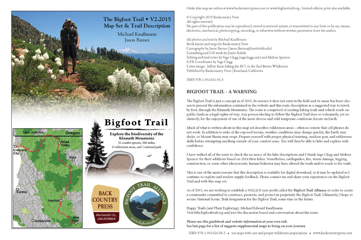
Yolla Bolly Permutations

pərmyo͝oˈtāSH(ə)n

The action of changing the arrangement, especially the linear order, of a set of items (what came first, the conifer or the cone?)


Wandering Devil’s Hole Ridge, miles from anything human, the landscape shifts as quickly as the juncos dancing across the trail. Walkabouts bring a level of focus not found in civilization. Walking offers time to hypothesize about the world at a slower pace…How recently did the vegetation patterns I see come to be? When did the Ash-throated flycatcher arrive from its tropical winter-land? How did I find myself in this desolate, isolated place–seven years after I last visited–and so far from my family? Like the undulating contours on the ridgeline, I ponder my place in this dynamic world. Walking further I realize, while out of place, I am fortunate to be here with time to think.

Along the Bigfoot Trail in the Yolla Bolly-Middle Eel Wilderness

Seeing the trees through the forests, the birds in those trees, and then this vast landscape through my astigmatized-wide-angle glasses; thoughts swirl through my mind. The first few hours allow time to come to terms with my isolation and my body’s age (I’m moving slower than when I was here in my 30’s). Slowly my mind settles into place, in the wilderness. I ponder plant migrations and vegetation patterns as a student of biogeography. A few miles later my mind drifts towards systems of order (and disorder) that are established out here. This is where true place-based interpretations begin to solidify: my understanding of wilderness and how I’ll never truly fit in among it. Then comes the delineation of rarity. I am a rare human here–among the trees, sky and soil–but this fanciful journey is for the rare plants of the Yolla Bolly-Middle Eel.

Continue reading “Yolla Bolly Permutations”

Bigfoot Trail Map Set – V2.2015

I first created a map set for the trail in the winter of 2009 after hiking the trail the previous summer. It was a fun, first attempt for me to create something like this. I offered the digital map set & route description for free the past 6 years (find original map set here). During that time, hundreds of folks downloaded the file. Some of those even hiked the trail, providing me feedback on the original description. With the launch of my grand plan to establish the Bigfoot Trail Alliance, I decided it was time to revamp and update the previous document.

Bigfoot Trail map set V2.2015 cover pages.

That original file got a major overhaul this spring with the help of a terrific cartographer, Jason Barnes. He and I worked out a template for the route and then created 23 brand new maps. At a scale of 1:60,000, where one inch is a mile. The description has a new, more user-friendly look and Jason’s map layers are second to none for both beauty and navigability.

Here are the details from the cover page of the new map set:

All photos and text by Michael Kauffmann
Book layout and map details by Backcountry Press
Cartography by Jason Barnes
Consulting and GIS work by Justin Rohde
Editing and trail notes by Sage Clegg and Melissa Spencer
GPX Coordinates by Sage Clegg
Published by Backcountry Press | Kneeland, California

ISBN 978-1-941624-04-3

Take the maps for a walk (long or short) and enjoy one of the most biodiverse temperate coniferous forest on Earth.

Section1_Bigfoot-Trail-Map
Bigfoot Trail section 1 – V2.2015 map set.
Bigfoot Trail section 23 - V2.2015 map set.
Bigfoot Trail section 23 – V2.2015 map set.
authors
Jason Barnes (left) and Michael Kauffmann (right)

Bigfoot Trail Presentation

I’ll be sharing a Bigfoot Trail Presentation exploring the hike and the natural wonders along the way for this month’s meeting of the California Native Plant Society, North Coast Chapter. I hope you can join me!


BFT Route
BFT Route

“The Bigfoot Trail: A Celebration of Klamath Mountain Flora.” 

May 13, Wed. 7:30 p.m. At the Six Rivers Masonic Lodge, 251 Bayside Rd., Arcata.

The Bigfoot Trail travels 360 miles across the Klamath Mountains from the subalpine slopes of the Yolla Bolly-Middle Eel Wilderness to the temperate rainforest in Crescent City. Michael Kauffmann, the trail’s originator, will take you on a photographic journey along the route to celebrate the region with both the common and rare plants along the way, including 32 species of conifers. Visit www.bigfoottrail.org to preview the route. To get ready for summer hiking, an updated map set and write-up for the route will be available for purchase, with a portion of the proceeds going to North Coast CNPS. Michael’s new book, A Field Guide to Manzanitas, will also be available with all proceed going to North Coast CNPS.

The Bigfoot Trail is a journey to discover the natural history of the Klamath Mountains.

Also, coming soon…

Sound Ecology – Klamath Mountain Conifers

I was recently asked by KHSU, here in Humboldt County, to write a two minute script for their Sound Ecology series. I chose to write about the conifers of the Klamath Mountains. I hope you enjoy this piece and are planning your next adventure into this botanical wonderland.


Here are the activities I will be a part of in the coming months, please join me!


May 11th, 2015 Backcountry Press presents:

A Field Guide to Manzanitas:
California, North America, and Mexico

Michael Kauffmann, Tom Parker, and Michael Vasey
Photographs by Jeff Bisbee

Stay Tuned!

Creating the Bigfoot Trail Alliance

My high school biology teacher inspired my love for natural history. After hiking the Continental Divide Trail, I fell in love with long-distance hiking. The The Bigfoot Trail combines the two.

Eminent botanist John O. Sawyer and I once discussed the lack of connectivity between the wilderness areas in the Klamath Mountains. This led us to pour over maps, talk rare plants, and plan a path that would connect these wild places. In 2009, I first walked this route and over the past few years have re-hiked various pieces to “finalize” the trek I call the Bigfoot Trail. This project combines long-distance hiking and natural history by defining a thru-hike in one of the most species-rich temperate coniferous forest on Earth.

The Bigfoot Trail Alliance

I recently launched a Kickstarter Campaign to fund the establishment of the Bigfoot Trail Alliance (BFTA) as a 501(c)(3) non-profit organization. The BFTA will create a community committed to constructing, promoting, and protecting—in perpetuity—the Bigfoot Trail. I am asking you, noble reader, to become a founding member of this organization.

CLICK HERE FOR RADIO INTERVIEW ABOUT THE CAMPAIGN

In my time living in northwest California, I have fallen deeply in love with the uniqueness of the Klamath Mountains. So much so that I wrote a natural history and hiking guide called Conifer Country which documents and celebrates the region. While writing that book, I hiked thousands of miles in search of wild trees.

The trail begins on the subalpine slopes of the Yolla Bolly-Middle Eel Wilderness, traverses the Klamath’s most spectacular peaks, crosses all its wild rivers, and ends at the edge of the continent in the temperate rainforest. It highlights all that Conifer Country has to offer.

The Bigfoot Trail Route

I believe that by establishing this route—and ultimately the BFTA—a deeper understanding and awareness will be fostered for this region. This trail, and organization, is about the other biota who live in the Klamath Mountains—ultimately to function as stewards for their protection.

Please follow this link to join the campaign to establish the Bigfoot Trail.