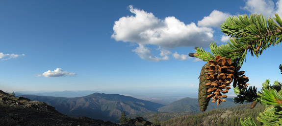
Mount Linn–also called South Yolla Bolly Mountain–is the highest point in the Coast Range of northern California. It is located to the west of Corning but the area might as well be a world away from the population centers of the state; it is rarely noticed by travelers as they drive Interstate 5. Once off the interstate, scenic forest service roads still take nearly 2 hours to wind to the trailhead. Although this place has always been on my list of places to visit–the impetus for this visit was to collect some samples of the rare Sierra juniper (Juniperus grandis) for Robert Adams of Baylor University so that, through DNA testing, he might find out if these trees truly are what we think they are (see previous blog). After a 25 mile sojourn deep into the wilderness to collect those specimens it was time to search for the southern most stand of foxtail pine in northwest California–on Mount Linn.
The distinct cones and “bottle-brush tassle” branches help to identify Pinus Balfouriana.
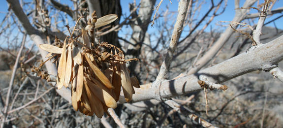
Ash Meadows National Wildlife Refuge is located along the eastern border of Death Valley National Park. The area presents an incredible juxtaposition to the desert — lush springs feed streams lined with riparian species; many of which are relicts of a wetter time. In this arid region, when precipitation befalls the mountains of southwestern Nevada, water percolates into aquifers. Over nearly a millennia this primordial water flows underground; forming the headwaters of the aboriginal Amargosa River. At Ash Meadows, these waters are forced up from the underground and a brilliant system of springs can be witnessed; in the heart of some of the most arid land on earth.
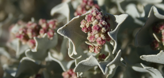
The velvet ash (Fraxinus velutina) for which the refuge is named
In wetter times of the Pleistocene the Amargosa River flowed here, connecting a system of lakes — all the way to the once-massive Lake Manly. This lake is now dry and known as Death Valley. As this system of rivers and lakes dried with time the fish became restricted to where water remained above ground. Today, Ash Meadows holds the bulk of these springs and hence — through speciation events due to geographical isolation — numerous species of pupfish. It is said that AMNWR has the greatest concentration of endemic life in the United States — at least 25 species have adapted to environments in and around the springs. Again, riparian relicts of and epoch gone by.
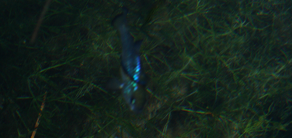
The Ash Meadows Amargosa pupfish (Cyprinodon nevadensis ssp. mionectes) thrive at Jackrabbit Springs.
The pupfish of the region behave as the cichlids of the African Great Lakes — being highly territorial and breeding in a around rocky shelves. Where as the African cichlids are an example of parapatric speciation, the pupfish of Ash Meadows exhibit allopatric speciation — because of their geographic isolation over time.
The region is still threatened. As water levels dropped to feed farms in the 1960’s, the level of water in the underground aquifer dropped and habitat for the Devil’s Hole pupfish (Cyprinodon diabolis) began to disappear. A Supreme Court ruling in 1976 limited the pumping of water and, for now, has saved this species — as the water remains at a level necessary for breeding near a prefered limestone shelf. The Devil’s Hole pupfish, because it lives in only one place — a litteral rock-hole-spring in the middle of the desert — is possibly the most environmentally restricted species on Earth. This area needs us to visit, to foster our understanding of the unique biota living on our planet.
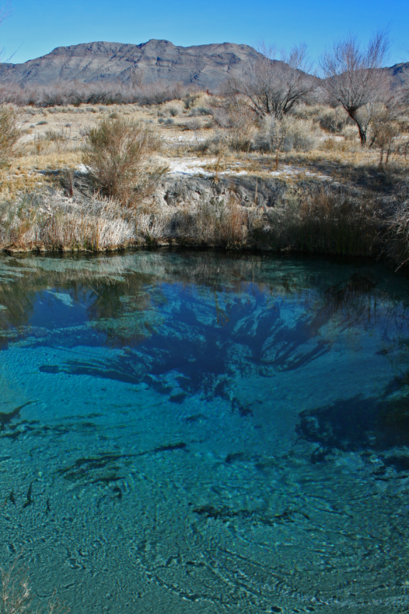
The swirling emerald-blue water of Crystal Spring.
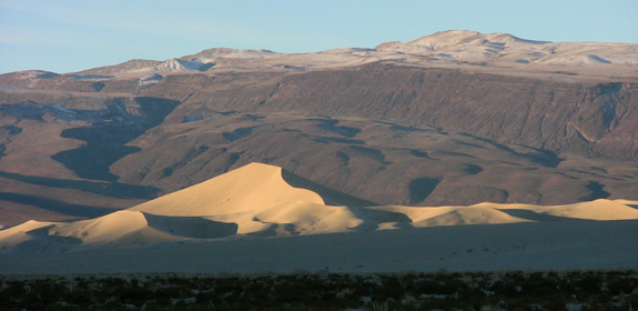
One of the most visually spectacular destinations of all desert landscapes in North America has to be the Eureka Dunes of Death Valley National Park. At the end of the Pleistocene an ancient lake that filled the valley floor gradually dried up; as the winds blew newly exposed sand the dunes formed — into one of the highest in North America. The highest dune in the complex rises to 650 feet above the valley floor from which the surroundings are a terrific spectacle to witness. Another fascinating feature of the dunes is their propensity to sing or boom when the sand is pushed from a steep slip face. The sound reverberates from inside the dune as a deep bass note — which is sure to amaze.
Looking south to the Eureka Dunes and Saline Range at sunrise.
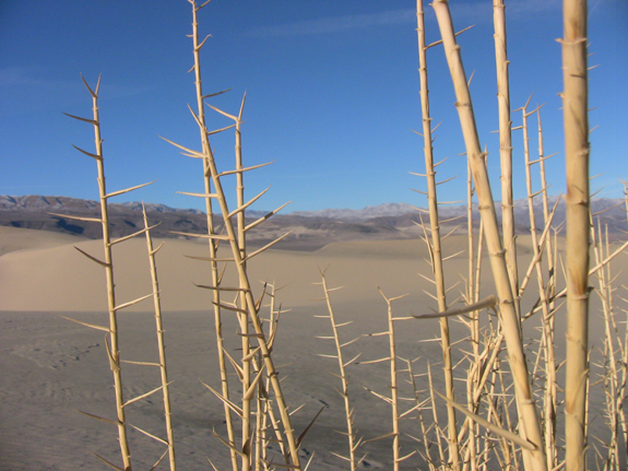
The valley not only offers visual beauty but endemic biota as well — currently 3 endemic plants and 5 endemic beetles have been identified on the dunes themselves. The Eureka Valley dune grass (Oenothera californica ssp. eurekensis) was the most spectacular to find on our winter trip. I had never seen a grass that looks like this — quite primordial indeed. The other two endemic plants on the dunes are shining milk vetch (Astragulus lentiginosus var. micans) and Eureka Dune evening-primrose (Oenothera californica spp. eurekensis). Though we saw the astragulus, both are best viewed in early spring when in bloom.
The endemic Eureka Valley dune grass.
The legendary plant explorers of the Eureka Valley are Mary and Paul Dedecker. As self taught botanists they often explored the Mojave looking for plants. One a fateful day in the summer of 1975 the two ventured into the Eureka Valley and eventually into a canyon on the south side of the valley. It was a hot July day when Mary found a shrub in bloom — bright yellow when all other plants were browning in the summer heat. It turned out the this was a new species and a new genus that favors a rare limestone outcrop in the canyon. She aptly named the plant July gold (Dedeckera eurekensis). The canyon itself was later named Dedeckera Canyon and can be traveled (with 4-wheel drive and experience) all the way to Saline Valley.
Dropping down the dry falls of Dedeckera Canyon from Saline Valley
COMMENT: AUTHOR: Thomas Lopez DATE: 10/8/2009 12:34:22 AM Very nice photos, hope to visit the area sometime for an Ansel Adams experience, that is photographing the dunes and surrounding area with a large format camera and b/w film. —– COMMENT: AUTHOR: Lenavena EMAIL: lenevana@gmail.com URL: https://www.wildlifeworld360.com DATE: 11/1/2010 11:24:58 AM Awesome photos. Will visit it sometime —– COMMENT: AUTHOR: Dave Imper DATE: 11/15/2010 5:56:35 PM Fantastic pics Mike. I took the road between Eureka and Saline Valleys as well, back in about 1997…brutal. Glad I had a rented car. Did you see the Marble Bath, noted on the USGS quad? Not what you expect. We need to share our desert trip photos.
Dave- I have done that road twice and missed the Marble Bath each time–guess it was a bit stressful from Saline to the saddle and I was distracted when we passed that spot. -Michael
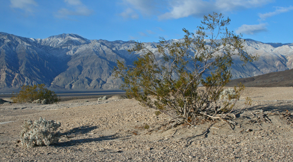
Saline Valley might just be the most isolated spot in the state of California. In many aspects it is a smaller version of Death Valley, just to the east. It has a wide basin with a smaller sand dune complex, is surrounded by mountain ranges — including the Inyo, Nelson, Last Chance, and Saline — and has terrific canyons to explore full of lush springs and hanging gardens. One major difference to its neighboring valley is that it exposes several hot springs to the surface that have been known and used for centuries. Most of Saline Valley is in Death Valley National Park — the base of the massive Inyo Mountains to the west is the boundary between park land and National Forest.
Creosote and desert holly typify the flora that is likely to be found on the valley floor. The Inyo Mountains are in the background.
Creosote (Larrea tridentata) is the most dominant shrub of the valley floor — and possibly the most successful shrub in the deserts of North America. The species covers 149 million square miles, ranges in elevation from -235 to 5,000 feet, can live at a density of over 350 plants per acre, and some argue that this species may live as long as 11,000 years (Pavlik 2008). One adaptation to survive in these harsh desert conditions is its small leaves, which grow at angles that minimize direct contact with the sun’s rays. Desert holly (Atriplex hymenelytra) is a common associate of the creosote, and also a common shrub in Saline Valley. This species survives in harsh desert conditions by having angled, light colored leaves.
Creosote was in flower on our December visit.
Saline Valley has a long history. The Timbisha Shoshone inhabited the area until the late 1800’s when the mineral rich region enticed prospectors into an isolated existence — mining silver, gold, borax and, even salt. Now, the main attractions are hot springs and isolation. There are a series of 3 springs spread out over several miles in the southeast corner of the valley. They are very popular with desert rats — colorful stories are the norm while soaking in the tub. The most infamous visitor to the springs was Charles Manson, who spent time in the valley in the 60’s before being caught further south in the park.
Desert holly in bloom.
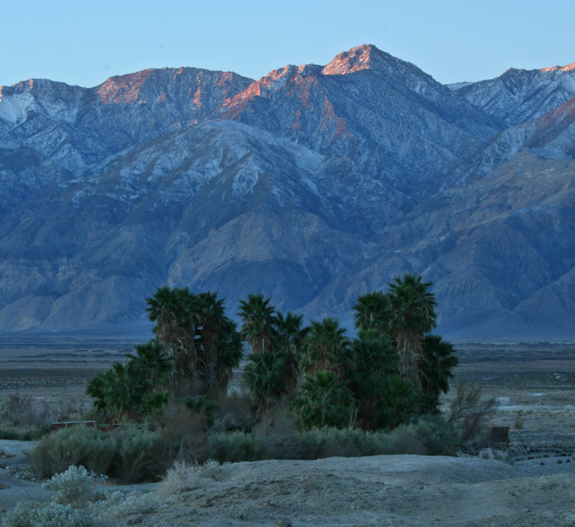
Sunrise on the Inyos towers over the lower springs — decorated by introduced California fan palms (Washingtonia filifera)
When I visit the Lanphere Dunes I always feel like I have taken a trip to another part of the world. Hidden and relatively unknown, the redwood forest — as a local destination — can overshadow this unique ecosystem. The dune complex is surrounded by temperate coniferous rainforest, the Pacific Ocean, and Humboldt Bay — ecologically trapping and therefore fostering, for millenia, isolation of space and time. Species that survive here define their own vegetation type; from the common to the unexpected, to the seemingly out of place there is always something new to appreciate on a trip to the dunes. Although a visit requires a guide or written letter of permission, hikes are offered monthly — check the Humboldt Bay National Wildlife Refuge webpage for information regarding access.
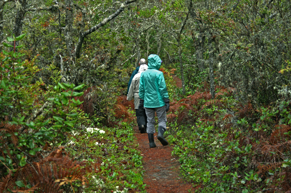
In between dune complexes, forests thrive where they are sheltered — out of the wind.
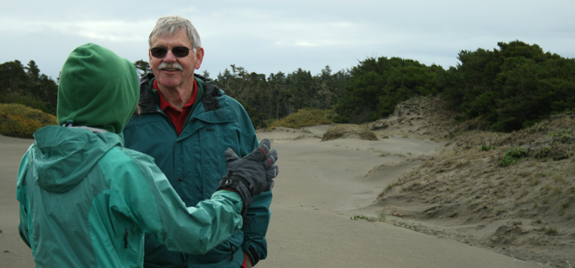
Today, we were lucky to have a guide. Allison and I joined Dr. John Sawyer and his wife Jane on a walk through the dunes. John was a key member of a group of conservationist with a vision — that originally secured preservation for this area nearly 40 years ago. Since the establishment of the preserve, it has changed hands from the original steward, the Nature Conservancy, to the Fish and Wildlife Service who manages it today — with a mostly hands off approach, except toward the removal of non-native species, the place has maintained a primordial feel.
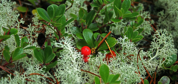
Kinnikinnick (Arcotstaphylos uva-ursi) and reindeer lichen (Cladonia rangiferina) carpet the forest floor.
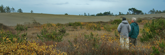
As the sand shifts south the vegetation soon follows. Here, John Sawyer and I observe young beach pines sprouting where the sand has recently (over the past 25 years) blown away — creating a more stable soil medium.
Lanphere dunes foster an amazing range of biota. From rare plants to common plants to plants that are far from their more common range — expect the unexpected when venturing into the dunes. Besides some terrific conifer specimens, including a subspecies of lodgepole pine called beach pine (Pinus contorta spp. contorta), the most intriguing inhabitants in the dunes are reindeer lichen (Cladonia rangiferina) and bear berry manzanita (Arcotstaphylos uva-ursi). The lichen is a common component of northern boreal forest floors where it grows circumpolar in the northern hemisphere — the Lanphere Dune population is a relict from a much colder time. Bear berry, or kinnikinnick, is a beautiful, prostrate manzanita that is found elsewhere in California in a few drainages on the east side of the High Sierra Nevada — dunes and high mountains, quite a contrast in habitats. One species that caught Allison’s eye was a population of twin flower (Linnea borealis); a plant we have grown to love on our summer forays into the Klamath Mountain high country. Dr. Sawyer informed us that the population Allison spotted was the only one discovered one in the dune complex — another relict of an epoch gone by.
Allison and John passionately discuss the seed dispersal of the Humboldt Bay wallflower (Erysimum menziesii)
The dynamic ecosystems of Lanphere Dunes makes for an exceptional hike. This is a place that embraces change, while at the same time offers refuge to species that were once common in the region during climatically different times. It is surely one of the best examples of a coastal dune ecosystem on the Pacific Coast.
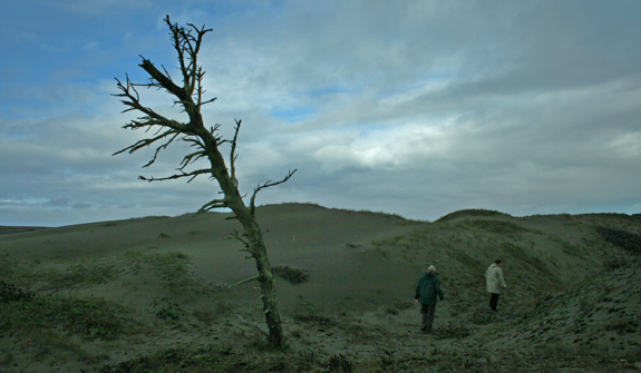
With ocean winds come shifting sand. When sand encroaches upon the forest trees die leaving “skeleton forests” — reminding the temporal visitor that the dune ecosystem is a dynamic one.
COMMENT:
AUTHOR: J Loomis
DATE: 5/2/2009 3:38:42 AM
Just returned from CA last Sunday. I was unable to tour the Lamphere Dunes not knowing it required a permit. Went to the nearby “Friends of the Dunes” Stamp D. area and was fortunate to find a single Wallflower….or what I thought was one. Anyone have any pictures?