Klamath Foxtail Pine

Pinus balfouriana ssp. balfouriana

“Whether old or young, sheltered or exposed to the wildest of gales, this tree is ever found irrepressibly and extravagantly picturesque and offers a richer and more varied series of forms to the artist than any other conifer I know of.”

−John Muir
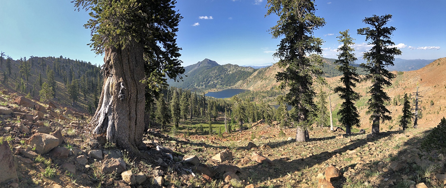
Epic grove of Klamath foxtail pines above East Boulder Lake.

The following excerpt is from my book Conifer Country. I was inspired to publish it here after a recent trip with my son to visit and measure the Klamath Mountain champion foxtail pine. After this trip, the foxtail pine is his favorite tree species too 🙂

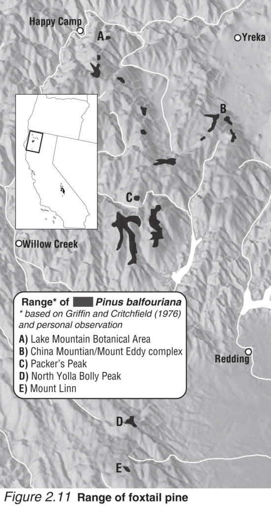
Klamath foxtail pine range map from Conifer Country.

California’s endemic foxtail pines have established two esoteric populations abscinded by nearly 500 miles of rolling mountains and deep valleys. The species was first described by John Jeffrey near Mount Shasta in 1852 , which was most likely a population near Mount Eddy or in the Scott Mountains. Later, this species was discovered in the high elevations (9,000’-12,000’) of the southern Sierra Nevada. The ecological context of Klamath foxtail pines in the Klamath Mountains differs drastically from that in the Sierra Nevada due to the divergence of these populations in the mid-Pleistocene. Though separated over one million years ago, both subspecies exhibit a radiance and individuality for which I honor them as my favorite conifer.

With separation in space and time, divergence—including cone orientation, seed character, crown form, foliage, and even chemistry—has occurred between the two subspecies. Another reason for these variations are genetic bottlenecks that have been promulgated by spatially restricted microsite adaptations, particularly in the Klamath Mountains . Northern foxtail pines (var. balfouriana) are isolated on sky islands—local mountain tops and ridgelines—from 6,500’ to 9,000’ in the eastern half of the Klamath Mountains. By my count there are 16 isolated sub-populations each consisting of one to several isolated mountain-top populations, except in the Trinity Alps where they are locally common in the more contiguous high elevations. On these sites, proper geologic, topographic, and climatic conditions have offered synergistic alliances with shade-tolerant and faster-growing firs and hemlocks.

Continue reading “Klamath Foxtail Pine”
Pacific Silver Fir in California

Part 1: The Siskiyou Crest

Read Part 2

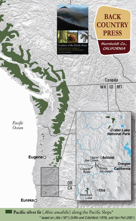
Pacific silver fir range map from Conifers of the Pacific Slope.

In conjunction with the Klamath National Forest and the California Native Plant Society Vegetation Team, I began a mapping and inventory project for Pacific silver fir (Abies amabilis) in California. The first part of this project was along the Siskiyou Crest, near the Oregon-California border. Later this summer I will visit the other population in the Marble Mountain Wilderness.

Pacific silver fir in California can easily be overlooked because of its similarity to white fir (Abies concolor). Upon close inspection (and by going to specific locations) the differences will become apparent. Silver fir is identifiable in the hand because it has the most distinct and exuberant stomatal bloom of any regional tree. Like grand fir (and regionally white fir) the tips of the needles are notched. The needles splay from the branch on only one side often in a perfect arrays, fanning out in a semi-circular manner. The needles occasionally twist in this array, thus offering distinct silver flashes of the stomatal bloom on the undersides—a brilliant contrast to the dark-green upper surfaces. This is also what sets it apart from white fir, with a duller stomatal bloom. As with other Abies, the smell of crushed needles emits a resinous “pine scent.” The bark is distinct, forming long, narrow, rectangular blocking patterns that seem to melt off the trunks in silvery chunks with subtle reddish hues in the furrows. At a distance, larger trees are gradually tapered, similar to Shasta fir (Abies magnifica var. shastensis). It is an inimitable and rare experience to spend time with this beauty in the Klamath Mountains

Continue reading “Pacific Silver Fir in California”

San Gabriel Mountains Presentation

Plant Exploring in the San Gabriel Mountains National Monument

Wednesday, May 11, 2016 @7:30 p.m. at the Arcata Masonic Lodge

From the California Native Plant Society North Coast Chapter:

Explorer, writer, and educator Michael Kauffmann will lead us on a journey into the Transverse Ranges of southern California to explore the world of what John Muir called the steepest mountains in which he ever hiked. Michael’s explorations began because of a Bigcone Douglas-fir mapping and monitoring project he is leading in conjunction with California Native Plant Society, but these studies have allowed him to make more discoveries–from one of the world’s largest oaks to the most isolated grove of Sierra junipers in the world. Michael will take us on a photographic journey from the mountain tops to the river canyons across one of the nation’s newest national monuments.

San Gabriel Mountains

Klamath Mountain Snowpack

Pondering the 2016 hiking season…

I have tracked how Klamath Mountain snowpack is correlated with the beginning of summer hiking season since 2003. In 2009 I started the Bigfoot Trail on the summer solstice, and it worked out perfectly—I found the perfect mix of snow, open trail, and manageable river crossings. 2010 was a late snow year and June was only open for hiking in the Southern Siskiyous. In 2011 I began a section hike from the Trinity Alps to the Siskiyous on June 29th in a snowstorm and we trekked across snow for nearly two weeks while in the Trinity Alps and Marble Mountains. Our time also included numerous, often stressful, fords of raging rivers in the low-country. What follows is an analysis of the El Niño winter we are emerging from and what snowpack trends seem to be saying about the 2016 hiking season.

2011-Alps
2011 section hike — crossing Stuarts Fork in the Trinity Alps and snowfields in the Marble Mountains

Continue reading “Klamath Mountain Snowpack”

Cory Peak Botanical and Geological Area

Original Publication DATE: 6/17/2014

There are celebrated regions of the Klamath Mountain–preserved and maintained for our enjoyment as monuments or wilderness–and there are others with little or no designation beyond National Forest land. How does the outdoor enthusiast find these little-known places? In the case of the isolated botanical areas of the Scott Mountain Crest, the main route in and out is on the Pacific Crest Trail.

Untitled_Panorama3
The Pacific Crest Trail contours the eastern ridgeline through the Cory Peak Botanical Area – shown here by Bull Lake – with the Trinity Alps in the background.

Continue reading “Cory Peak Botanical and Geological Area”

Ecological Amplitude: A story of climax

Original Publication DATE: 7/15/2011

Box Camp Mountain | Marble Mountain Wilderness

Ecological amplitude is the range of habitats, often dependent on and defined by elevation, within which a certain species has the ability to survive. In the Klamath Mountains there are two species of pines that define the highest elevations–growing at or near the summits of peaks from ~7500′ to 9000′ (The Klamath Mountains get no higher). Foxtail pine (Pinus balfouriana) and whitebark pine (Pinus albicaulis) inhabit our sky islands where they are the crowning jewels of this coniferous wonderland.

IMG_6853
Jeffrey Kane ponders the approach to Box Camp Mountain from the Pacific Crest Trail.

Box Camp Mountain is interesting for several reasons. The first is that its summit is only 7,267′ yet both species of said pines live in this fringe habitat. This is generally on south-facing slopes where lack of competition from firs and hemlocks (which thrive on north-facing slopes) is minimal. When approaching the summit I began to doubt the reports of these pines being here; but in the last few hundred feet they began to appear. Throughout Holocene warming, these two species (and others) have slowly been retreating up  regional mountains. Now, after thousands of years, they have reached their ecological climax on Box Camp–there is no more up on which to grow. This mountain holds the most formidably presumptive story I have attempted to read in a high elevation Klamath landscape–and what I read does not appears to have a happy ending.

Continue reading “Ecological Amplitude: A story of climax”

Red Buttes Wilderness | Recognizing Wild

Original Publication DATE: 7/13/2011

Our adventure began in the heavy rain of late June. We waved farewell to Allison from the Canyon Creek Trailhead to walk the Bigfoot Trail–in search of wild plants and places–for two weeks. As we climbed into the Trinity Alps it was doubtful we would be able to hike very far because of heavy snow and high water. On our second day, as the rain cleared, we approached the dangerously swift Stuarts Fork and were, for a moment, stopped by Mountains and Water.

Print
Wet weather, heavy snow at the passes, and swift creek crossing typified the first week of hiking through the Trinity Alps, Russian Wilderness, and Marble Mountains. Bottom left is the crossing of Stuarts Fork in the Alps–without that log, the trip would not have happened.


Continue reading “Red Buttes Wilderness | Recognizing Wild”